|
|
|
|
  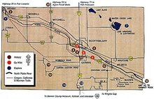 Scottsbluff Nebraska Map with Area Attractions numbered Large Map size with descriptions below |
|
| Sandhill Crane Migration | l | Toadstool Geologic Park | l | Nebraska Interactive Maps | l | Deer Running in Yard Video | l | Western Nebr Road Trip |
|
|
Below is a detailed Scottsbluff, NE Map Image with the local Attractions labeled and briefly described. No working Attraction Links, but does have phone numbers of the Local Scottsbluff Attractions. A very handy Nebraska map from a Scottsbluff Tourism Site that now seems to no longer exist. Thank goodness had made this Scottsbluff, Nebraska Attractions Map copy earlier. |
|
|
|
 Â
 |
|
Toadstool Geologic Park in the Chadron, NE "Badlands" area northwest of the Western Nebraska Sandhills -- plus Hiking Trail Info and Photo Gallery (Some High Resolution Photo Versions are now also available.)
Nebraska Maps - Interactive & Printable - for planning great Nebraska Road Trips
         Gene
forwards to a page of Links with descriptions for this, + our Affordable US Beach & Fall Foliage Vacation Guide Sites + Sunset Photos Gallery
-- easy to remember to come back to any of our US Vacation Sites! Â
Thanks for dropping by -- come back and visit us soon for
Info on your next Affordable Nebraska Travels -- or to check out our latest Picture and Video additions!    Gene - - send your comments or suggestions -- or share your own Scottsbluff NE Travels and Nebraska Sandhills or Panhandle favorites or pictures. We appreciate your comments and feedback! Â
|