|
|
|
|
  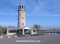 Historic Lake Minatare Lighthouse near Scottsbluff NE Nebraska Lighthouse without a Light |
|
| Sandhill Crane Migration | l | Toadstool Geologic Park | l | Nebraska Interactive Maps | l | Lincoln NE Attractions | l | Western Nebr Road Trip |
|
|
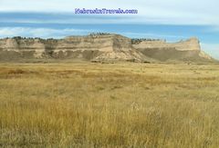
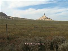
"Must See's"-- Scotts Bluff National Monument - Chimney Rock National Historic Site -
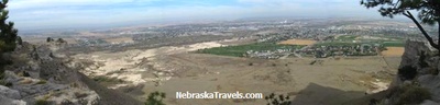
Check out the National Park Service with history and science links, plus a helpful "plan your visit" link including a map and visitor center Information with hours and fees. Click this link for of the Site. The Scottsbluff National Monument Site is a definate Scottsbluff NE area "Must See" Wildcat Hills State Recreation Area and Nature Center - 8 mi. S. of Gering on NE Hwy 71 - Rugged and beautiful country - has great hicking trails + picnic facilities. Great for backpackers. Includes a game reserve with buffalo and elk. This Link goes to the page on the Nebraska Game and Parks Web Site. On the way down to Wildcat Hills State Recreation Area, don't miss the very scenic 23-mile gravel driving "Road to Robidoux Pass." The westbound Oregon Trail traffic went through this pass. The drive starts out 1 mile south of Gering on Hwy 71 and goes west 8 miles on the gravel Robidoux Road. You will go by the reconstructed Robidoux Trading Post - follow the signs to Summit Ranch Road and then Carter Canyon Road back east to Hwy 71 - road comes back to Hwy 71 a few miles north of Wildcat Hills State Recreation Area.
Lake Minatare State Recreation Area and Lighthouse - About 7 miles NE of Scottsbluff, NE - 9 mi. north of town of Minatare on Stonegate Rd. Lake Minitare is a State Recreation Area with more than 2,000 acres of water. There were several fisherman out in boats the last time we were there and it looked like the fishing was good. Camping, picnicking, and swimming are also available.
If you enjoy Historic Lighthouses and Scenic Lakes, the Lake Minatare Lighthouse and Lake Minatare Recreation Area are a "Must See" 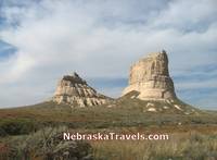 Courthouse and Jailhouse Rocks near Bridgeport, NE - on Oregon trail Courthouse and Jailhouse Rocks - 5 mi. S. of Bridgeport (on Hwy 92) - South on NE Hwy 88 - These unusual rock formations are accessed by a well marked gravel road going west off of Hwy 88. They were one of the trail "markers" on the Oregon Trail. No Visitor Center or facilities are available. This link goes to a page on the Bridgeport Nebraska Web Site Agate Fossil Beds National Monument - about 32 miles north of Scottsbluff, NE on Hwy 29. 24 mi. S. of Harrison, NE on the way north up to the Crawford and Chadron area. The Visitors Center and Museum displays many fossils of ancient animals and American Indian artifacts from 31 Native American tribes. The internationally recognized Agate Fossil Bed Site contains a very narrow Niobrara "stream" area not too far from the point of origin of the Niobrara river + some interesting walking trails among the quarries. American Indian artists show their art on some weekends during the summer months. This link goes to an on the National Park Service Web Site with a Map + links to the Agate Fossil Beds Visitors Center and Museum activities dates and hours open + fees. See many pictures and more Geology fieldnotes information on this of the NPS web site. If you are interested in the recovery process for ancient fossils and viewing Indian Artifacts, the Agate Fossil Beds National Monument Site is a "Must See" Read Candid User Reviews and Ratings + compare prices of Scottsbluff area Hotels and Motels at this page. for Scottsbluff, NE. Back to top of Scottsbluff, NE "Must See" List A listing of some of the pages on this Nebraska Travels Site now, plus some of the pages and pictures to come are in the Menu listing to the left. More are being added as we think of additions that would be interesting to our Site visitors -- especially topics that we currently have pictures for since this is a "picture enhanced" Site. We took over a thousand pictures + a few videos from our last road trip vacation through the Nebraska Sandhills and the Western Nebraska Panhandle, so we have a few pictures to choose from. The list of the pages here now + descriptions is below.
         Gene
forwards to a page of Links with descriptions for this, + our Affordable US Beach & Fall Foliage Vacation Guide Sites + Sunset Photos Gallery
-- easy to remember to come back to any of our US Vacation Sites! Â
Thanks for dropping by -- come back and visit us soon for
Info on your next Affordable Nebraska Travels -- or to check out our latest Picture and Video additions!    Gene - - send your comments or suggestions -- or share your own Scottsbluff NE Travels and Nebraska Sandhills or Panhandle favorites or pictures. We appreciate your comments and feedback! |
 Â Â Â
     Â

|
|
|
  Â