NebraskaTravels.com top Logo - click to return to Home Page

  Nebraska Toadstool Geologic Park Trail - Nebraska Travels Attraction in Badlands area
  Toadstool Geologic Park Trail Picture
- in Nebraska Badlands - NW of Sandhills
- more Toadstool Park Photos below

Toadstool Geologic Park

In the Western Nebraska Badlands

Northwest of Chadron, NE
West of the Nebraska Sandhills

+ Pictures from the Educational and Fun Geologic 
  Toadstool Park Trail


"Tips to help you Plan & Save + Pictures to help you Dream"


NebraskaTravels.com
Home Page

Nebraska Maps
Interactive & Printable

New The Western Nebraska Road Trip
Sandhills + Panhandle + Photos

Northwest Nebraska Grasslands & Badlands Area

Chadron & Crawford Area Attractions
+ "Must See's" *
* check back

New Mari Sandoz High Plains Heritage Center

Toadstool Geologic
Park + Photo Gallery

- this page

Fort Robinson State Park *

Nebraska Sandhills Area & Attractions

Sandhills Area Info
+ Attractions
& "Must See's *
* here soon

Northern Nebraska
Niobrara River
& Parks Area

Niobrara River + Nearby Attractions *

Smith Falls Waterfall & Niobrara River Pict
+ Waterfall VideoNew

Western Nebraska Panhandle Area

Scottsbluff NE area Attractions - including Chimney Rock

+ Lake Minatare & Lighthouse *

Sandhill Crane Viewing on Platte Grand Island & Kearney

New Sandhill Crane Migration - Viewing Tips, Pictures & Video

Eastern Nebraska Attractions

Lincoln, NE area Attractions
& "Must See's" *

10 Deer Running in Back Yard Video
+ Deer Fight

Omaha area Attractions *

Indian Cave State Park near Brownville
- SE Nebraska *

Picture Albums
+ High Resolution 
Photos

New Nebraska Sunsets
Photo Gallery

+ free Screensaver
   Pictures 

New The Western Nebraska Road Trip
Sandhills + Panhandle
Many large Photos


Discount Tips Tips

Discounts for the
Over 55 Set *

Contact Us
- Your Comments
+ Site Map


Nebraska Toadstool Park is bit "remote"
   
- but a definite Western Nebraska Badlands "Must See" 

Toadstool Geologic Park is the extreme northwest corner of Nebraska - actually about 50 miles northwest of the western edge of the Nebraska Sandhills Region which is near Hay Springs, NE.


Toadstool Park, is in a remote area known as Nebraska's Badlands which is located in the Western Nebraska Oglala National Grasslands area.
(-- not near Ogallala, NE) It is about 18 miles northwest of Crawford, Nebraska -- which is 18 miles west of Chadron, NE. You go almost 5 miles north of Crawford on Hwy 71, and then about 13 miles west and northwest on a very scenic and well marked, but bumpy, gravel "Toadstool Road" to the Toadstool Geologic Park entrance.

There is a small day use and a overnight camping fee. Some of the publications we read said the park is open year-round, 24 hours a day -- but recommended against traveling on the gravel road to the park during or after a rain.


We would second the not driving on the gravel road when wet (and muddy?) advice.
Tip Tips More important - hiking on the trail and over the rocks could be difficult and possibly dangerous if they were wet and slippery.

Scenic Gravel Toadstool Road to Toadstool Park with long coal train - Nebraska Grasslands & Badlands area


Scenic but rough gravel road to Toadstool Park + long coal train approaching

A version of this picture is now on our US Vacation Sites High Resolution Photo pages - Pg 4


New Watch Video of this long loaded 200 car Coal Train passing (with some middle cars cut out). in remote area in western edge of Nebraska Sandhills where "Badlands" begin near Chadron, NE. Has engine sounds & train whistle.


The Toadstool Park Interpretive Trail Hike - the Nebraska Badlands

The spectacular rock formations and unusual examples of the effects of water and wind over millions of years make the Toadstool Geologic Park Trail Hike a definite "Must See" on any Western Nebraska Sandhills travels road trip. The Park is in the Oglala National Grasslands and is in a area sometimes called the Nebraska Badlands. Many unusual geologic formations are visible and the park has yielded some scientifically useful fossil deposits, some of which are still evident as "tracks" in the rocks.

The Interpretive Toadstool Trail is very well marked, and a detailed trail brochure is available that explains the numbered post markers along the one mile loop hiking trail. The park has 6 picnic and camping spots -- and we also found clean basic restroom facilities.
Don't expect running water when you are this far out in the "boondocks." You will need to bring your own water.


Toadstool Park Camping and Picnic area + trail view - Nebraska Badlands & Grasslands area


Toadstool Park Picnic and Camping area + view of the hiking trail beginning from parking lot.


A Western Nebraska Badlands "Must See!" - hidden 

Tip Tips The view when you pull up in the parking area next to the campsites and the interpretive sign area is impressive, but not nearly as spectacular as you will see on the Toadstool Park Interpretive Trail Hike, so don't pass up the educational and fun one mile loop hiking trail based on the view from the parking lot! The Trail Hike will take a little over an hour if you stop and take in all of the spectacular views and interesting rock formations.

My Wife and I rated the Toadstool Park Trail hike as one of the definate highlights of our most recent western Nebraska Sandhills Vacation road trip - a top pick Western Nebraska Panhandle and Sandhills Vacation "Must See!"


Young Kids on the Toadstool Park Hiking Trail?

We talked to a family that was just returning from the Toadstool Trail Hike with two girls that we thought were between 8 and 12, and they said they had no problems with the hiking trail that has some steep spots, some steep cliff drop-offs near the trail, and a few rocks you climb up and over.

Tip Tips We don't think the trail would be recommended for children 5 and under as parts of the trail would be difficult for an adult carrying a child which would likely be what would end up happening.

Toadstool Park Trail Interesting Toadstool Rock Formations - Badlands west of Nebraska Sandhills  

Toadstool Park Trail Interesting Rock Formations
- not visible from Trailhead
 
 
This picture is now on our US Vacation Sites High Resolution Photo pages - Pg 3 or 4


Toadstool Geologic Trail Hike Pictures!

Below is a series of pictures from our leisurely hike of the one mile Toadstool Park trail on a sunny Fall day in late October of 2006. The numbered Interpretive Brochure with pictures and drawings plus trail marker posts help make it very educational and interesting. Take plenty of film or have plenty of digital camera card memory when you start the hike -- it is a very "photogenic" trail as you can see from the pictures below.

Geology & History of Toadstool Park

This Geology of Toadstool Park link goes to a Chadron State College Web Site GeoScience topic area which has some very interesting information on how the various formations in Toadstool Geologic Park were formed by the forces of nature over millions of years + some pictures. Also a map page showing details of how to get to Toadstool park from Crawford, NE and some other nearby interesting Nebraska Grasslands attractions.

Picture Downloads

The pictures on this page are free to download and print or to use as Desktop Wallpaper or Screensavers as long as the  NebraskaTravels.com Domain Name text remains visibly displayed unaltered and readable on the image as it is on the pictures below. Resale of these images or pictures in any form or use on another web site without our permission is a violation

of our copyright, but we encourage you to ask, especially if it is for an educational use. Both my Wife and I were teachers once. Send to Gene Via Contact Us form.


Tip Tips We suggest using the larger images which will soon be on our upcoming screensaver Photos pages since the relatively small images on this page will appear "grainy" if try to enlarge them for use as desktop wallpaper or a screensaver image.

- OR - Some of the images below are now available as High Resolution Photo downloads + free watermarked "Comps" are available. More High Resolution Photos are being added. (Existing High Res Photos link below.)


Toadstool Geologic Park Photos Gallery
Taken on the Interpretive Hiking Trail


- in the Peaceful Western Nebraska Grasslands & Badlands


Toadstool Geologic Park Hiking Trail - fallen toadstool rocks - Oglala Grasslands west of Nebraska Sandhills - Midwest US


Toadstool Geologic Park Hiking Trail near beginning after you have entered the "U" shaped area with rock formations surrounding you on 3 sides - broken and fallen toadstool rocks - Chadron, NE area - Western Nebraska Grasslands / Badlands


Toadstool Park Hiking Trail - rounded fallen toadstool rocks - Badlands west of Western edge of Nebraska Sandhills


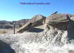
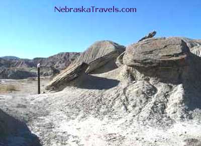
Toadstool Park Hiking Trail marker - rounded toadstool rocks where their softer rock "perch" has collapsed - the pole is one of the numbered Interpretive Trail markers that went with the brochure.
Near Crawford, NE west of Chadron
in the
Western Nebraska Oglala National Grasslands area - Northwest of Nebraska Sandhills


Toadstool Geologic Park Hiking Trail - Oglala National Grasslands area west of  Nebraska Sandhills


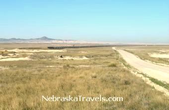
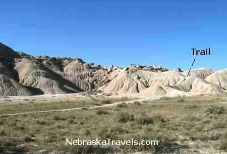
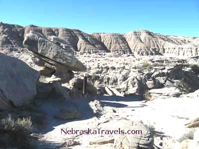
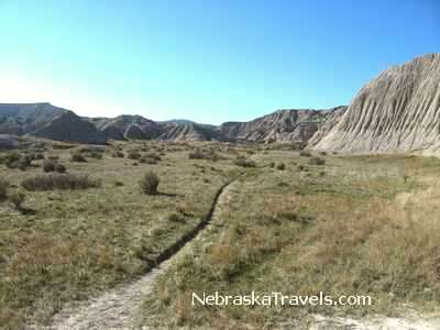
Toadstool Geologic Park Hiking Trail back into middle valley surrounded by rock formations - Western Nebraska Grasslands -Chadron, NE area - the Nebraska Badlands

  
This picture is now on our US Vacation Sites High Resolution Photo pages - Pg 3 or 4


Toadstool Park Hiking Trail rock formations - Nebraska Badlands west of Nebraska Sandhills


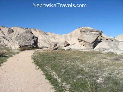
Toadstool Park Hiking Trail - some rounded fallen toadstool rocks + new formations emerging - Near Crawford, NE west of Chadron - Nebraska Badlands


Toadstool Geologic Park Hiking Trail wide angle - Badlands area west of  Nebraska Sandhills
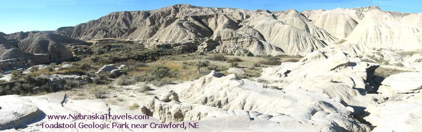
Toadstool Park Hiking Trail panorama view - valley surrounded by many rock formations
- In Western Nebraska Grasslands - three photos "stitched" together
Looks more like a landscape on the Moon rather than in Western Nebraska Panhandle near the Sandhills.
It is easy to see why this area is also called the Nebraska Badlands

  
This picture is now on our US Vacation Sites High Resolution Photo Preview pages - pg 3 or 4

Toadstool Geologic Park Hiking Trail - on top of formations - Nebraska Badlands area


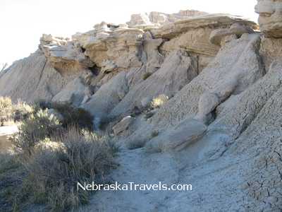
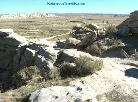
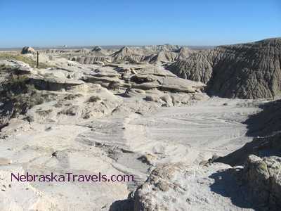
Toadstool Geologic Park Hiking Trail - on top of formations - This is an area where can see ancient animal "tracks" and fossils preserved in the rocks - Western Nebraska Badlands - Chadron, NE area
-- about 50 miles northwest of western edge of the Nebraska Sandhills.


Toadstool Park Hiking Trail rock formations on top - Nebraska Badlands area


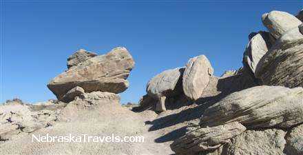
Toadstool Park Hiking Trail - surrounding rock formations view at top + interesting pointed rock on a toadstool-like perch
- in Oglala National Grasslands area west
of Chadron, NE
-- the Nebraska Badlands


Multi layered Toadstool at top - Toadstool Park Hiking Trail - Nebraska Badlands area west of Nebraska Sandhills


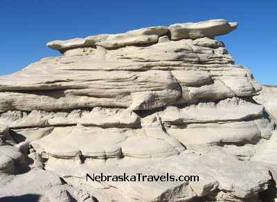
Multi-layered Toadstool on top - Toadstool Geologic Park Hiking Trail - Western Nebraska Grasslands in the Chadron, NE area


Looking back at end of Toadstool Geologic Park Hiking Trail - Western Nebraska Grasslands & Badlands area


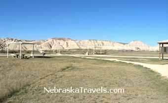
Toadstool Geologic Park Hiking Trail - on top of formations looking down on parking lot and trail head
- The two small brown "boxes"
toward the top right are
the rest rooms.
Peaceful Grasslands country.


Looking back at end of Toadstool Geologic Park Hiking Trail - Western Nebraska Badlands and Grasslands area

Looking back at the end of the Toadstool Park Hiking Trail - you can see where trail turns to left and goes up ridge, then turns right across ridge and then curves back to left at top of ridge toward rocks on top where you are coming from at the end of the mile long Toadstool Park Trail in the Nebraska Badlands.

This is a great educational and fun Western Nebraska Sandhills Vacation Attraction for ages about 6 and up. Parts of the trail seem like a walk on the Moon Vs in the Northwestern Nebraska Oglala Grasslands near the western edge of the Sandhills.


  • The pictures above and elsewhere on this Site are free to download and print or to use as Desktop Wallpaper or Screensavers as long as the  NebraskaTravels.com  or  SunsetPhotosGallery.com  Domain Name text remains visibly displayed unaltered and readable on the image as it is on the pictures above. Resale of these images or pictures in any form or use on another web site without our permission is a violation of our copyright, but we encourage you to ask, especially if it is for an educational use.

  • See these High Resolution Photos Preview pages for non-watermarked high resolution photo downloads from our three US Vacation Sites. Watch for more from this Site to be added there soon - the new additions from this Site will start out at the end on preview pages 3 or 4 and move forward as get more "views." Free "comp" picture downloads are available.

  • Mari Sandoz High Plains Heritage Center - prize-winning author - "Nebraska's Story Teller" - Display on Chadron State College Campus in Chadron, NE


  • New Sandhill Crane Migration - Pictures, Crane Links, & Viewing Location Tips + Video of thousands of Cranes flying in to roost for the night on the Platte River at Sunset and their unusual sounds!

  • Colorful Nebraska Sunsets Photo Gallery + Nebraska Country Sunrises & Free Screensaver Pictures - with High Resolution Photo Download Links

  • New The Western Nebraska Road Trip - the Nebraska Sandhills and Panhandle Road Trip Via the Scenic non-Interstate Route - Includes Nebraska National Forest and Scottsbluff area Attractions + Others. MANY great Pictures!!!

  • Deer Running Video - 10 Deer Running in Back Yard of an Acreage in Eastern, Nebraska + Popular Deer "Fight" Video and picture.

  • Smith Falls Waterfall & Niobrara River Pictures - Tallest Waterfall in Nebraska Pictures + Waterfall Video and Smith Falls State Park Info - a Nebraska Sandhills "Must See"

  • Nebraska Maps - Interactive and Printable - for Nebraska Road Trips and Attraction Areas

  • New Scottsbluff NE area Attractions and Points of Interest - including Chimney Rock and Scottsbluff National Monument


    Come back and watch our growth -- and check our our new picture postings!

        Gene

   Traveler to / Builder of:  NebraskaTravels.com
   Your Insider "Picture Enhanced" Nebraska Vacations Guide

 
 You can also check out our "Sister" Affordable US Beach Vacations Site
or our US Mountain Fall Vacations Site - both are also "Picture Enhanced" Vacation Guide Sites

 
Thanks for dropping by -- come back and visit us soon for Info & Tips on your next Affordable Nebraska Travels and Sandhills Vacations -- or to check out our latest Nebraska Sandhills and other Nebraska Picture and Video additions!


  Gene  - Contact Us - send your comments or suggestions -- or share your own Nebraska Travels and Nebraska Sandhills or Grasslands favorites or pictures. We appreciate your comments and feedback!


 To Home Page - NebraskaTravels.com - Nebraska road trips - An "Insider" Nebraska Vacations Guide - "Reviews" - Tips - Pictures


     Looking for something Specific that's not here yet?  Search our other two US Vacation Guide Sites.

Google
 
Web www.mountain-fall-foliage-vacations.com
www.memorable-beach-vacations.com


     To Top of Page - Nebraska Toadstool Geologic Park To Top of this Page - Nebraska Toadstool Geologic Park + Hiking Trail Info and Photo Gallery - the Nebraska Badlands northwest of the Western Nebraska Sandhills.


Copyright © 2006 - 2007    GoUSVacations.com Sites: NebraskaTravels.com   •  All rights reserved